After planning that started more than a year ago in cooperation with the Coastal Regional Commission and with input from local “stakeholders,” Brooklet officially has a new comprehensive plan, its first developed independently from the county.
Next, the city government of this growing town of at least 2,295 residents and 952 housing units – facts you can find among others in the spiral-bound copies of Brooklet Comprehensive Plan 2025 – will launch into an overhaul of its Zoning Ordinance, also with contracted assistance from the CRC.
A CRC consultant is scheduled to report to Brooklet’s appointed Planning and Zoning Commission during its 7 p.m. Tuesday, March 10, regular public meeting at City Hall as they start the zoning update process. But to reach more Brooklet residents, the CRC reportedly will also staff a booth at the Second Annual Hotdog Social Town Hall, starting at 6 p.m. March 12 in the Randy Newman Community Center.
Then more sessions will be scheduled, said Brooklet Planning and Zoning Administrator Melissa Pevey, the assistant city clerk.
“We want the public to know,” Pevey said. “I suggested having like a stakeholders’ meeting for all of our business owners about their zoning, and then also have a mixture of the residents – older residents, newer residents, incoming that just moved here residents – to get their point of view, from neighborhoods, individuals.”
The zoning work will review specific rules, regulations and zoning district boundaries for potential changes. Meanwhile, Brooklet Comprehensive Plan 2025 offers more general guidelines from a higher-level overview.
“It shows us who we are and are going to be,” Pevey said.
Adopted Thursday
Although it carries last year’s number because that’s when most of the work was done, the plan was formally adopted by Brooklet City Council with a 5-0 vote Thursday evening, Feb. 19, 2026. Previously, Brooklet has been included, along with the towns of Portal and Register, in comprehensive plans developed by the Bulloch County government, while the city of Statesboro has its own.
Now, Brooklet does too.
“This is the first time the town’s ever had our own comprehensive plan,” Mayor L.W. “Nicky” Gwinnett Jr. said after Thursday’s meeting. “As things grow, we just need to be looking at our own area and dealing with our own town.”
There was no further discussion of the comprehensive plan Thursday before or after Seat 2 Councilmember Bradley Anderon’s motion, seconded by Seat 3 Councilmember Rebecca Kelly, to approve the plan.
Over a year ago
But the first public hearing, advertised as “the kickoff” for the comprehensive planning effort had been held Nov. 14, 2024, followed by meetings with invited “stakeholders” signing in on Dec. 3, 2024, and then on Jan. 7, Jan. 28, Feb. 18 and April 15, 2025, before a second public hearing was held, “to receive input from the residents of Brooklet concerning the proposed amendment to the comprehensive plan” on Sept. 18.
The last page of the plan book is the “transmittal letter” signed by Gwinnett and dated Jan. 14, 2026, addressed to the Coastal Regional Commission’s office in Darien and submitting the plan for review by the CRC and the Georgia Department of Community Affairs.
The plan has 10 sections: 1. the Introduction, 2. Community Profile, 3. Vision & Goals, 4. Needs & Opportunities, 5. Land Use, 6. Housing, 7. Transportation, 8. Broadband, 9. the Community Work Program, and 10. the Report of Accomplishments.
Several of those areas might touch on Brooklet’s next area of CRC-guided planning, the Zoning Amendment update. But of course, the “Land Use” chapter is the part of the comprehensive plan that focuses on what zoning is all about.
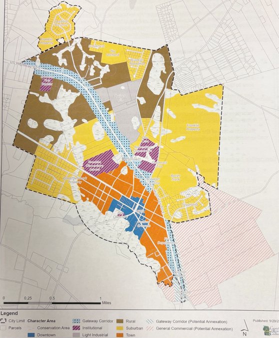
The comprehensive plan defines Brooklet’s existing zoning district categories and recommends four new zoning districts, but does not in itself alter the existing zoning map or rules. Instead, the high-level plan introduces a “character areas map,” which is one of the most colorful pages in the booklet. This feature was revised after public input, which Pevey said was one thing that caused the comprehensive plan work to take longer than first expected.
As now adopted by the council, the map in the comprehensive plan includes nine character area types: “Downtown,” is shown in medium blue. “Town,” shown in orange, is a larger residential area surrounding the downtown but including more residential blocks as well as commercial buildings. “Suburban,” mapped as large areas in yellow for single-family and limited multi-family residences, includes existing subdivisions as well as areas identified for development, such as the “Franklin property” and “Rozier tract.”
Gateway corridor
Brooklet’s “Gateway Corridor” character area surrounds U.S. Highway 80, extending up to 300 feet from the edge of the highway right of way on either side. Outlined in pale blue with black dots on the map, the corridor is recommended for C-2 “general commercial” zoning. It extends through town in this way but is not quite continuous. The map shows a section at the southeastern end the current Brooklet city limits where the “Town” area on the left of the map and the “Suburban” area on the right extend to the highway, with no commercial “corridor” in the middle.
“Our corridor tells where our commercial (area) is going to be and how the flow’s going to go downtown and still keep the structural integrity of the city of Brooklet down 80,” Pevey said. “So we were delayed a little bit because we fine-tuned that a little bit.
“We didn’t want Brooklet to be, as we grow, like anybody else where you just pass through on 80 and have just a whole bunch of businesses,” she explained. “We want to keep that small-town, historical feel.”
Pevey added that she will also work on having some portions of Brooklet recognized as historical districts but that this “will be in the far future,” with the zoning revision being the current priority.
Other character areas, as shown on the map, are “Light Industrial” in light gray, around Bulloch Gin and southeast of it; “Institutional” areas in crosshatched purple, including Brooklet Elementary School, the Recreation Department property, Brooklet First Baptist and the City Cemetery; “Rural” areas in brown, all in the northern to western parts of Brooklet’s expansive city limits; and “Conservation” areas, shown with grass-blade markings suggestive of wetland on a white background.
Beyond the current city limits on the southeastern end of town, the map also shows a faintly red-crosshatched area for “General Commercial (Potential Annexation).” A narrow band closest to Highway 80 suggests a little potential annexation extending the Gateway Corridor as well.
On an earlier page, the comprehensive plan lists Brooklet’s currently available zoning categories: A-1 agricultural, R-1 and R-2 single-family residential, R-3 multi-family residential, R-4 manufactured home community, C-1 general business district, C-2 general commercial, L-1 light industrial, L-2 heavy industrial, and F-H, “flood hazard.”
Four new zones?
“To support future growth,” the plan then recommends four new zoning districts it describes as “tailored to emerging development needs and community priorities.”
These would be a COD, or conservation overlay district, intended to protect conservation and open-space areas “that preserve rural character and natural features,” an MU, or mixed-use classification for combined residential and commercial uses in the same buildings or spaces, a DOD, or downtown overlay district, and the INS, or institutional classification for educational, government, religious or healthcare buildings.
Gwinnett said Brooklet’s zoning needs “a whole lot more clarity” than the current version and that he expects the revision process to take a minimum of six months.
The city’s six-month moratorium on rezoning and annexation requests remains in effect until mid-April, and could be extended by the council if needed, Pevey said.