
The Creek on the Blue Mile project is doable, but completing all the proposed public infrastructure aspects would likely cost between $40.2 million and $64.8 million, not merely the original $21 million in state funding and financing, consultants recently informed Statesboro city officials.
A more specific estimate of roughly $44.5 million was produced, but the consultants provided a range to comply with industry standards for construction cost projections in feasibility studies.
Engineers from the team led by the multi-state infrastructure consulting company Freese and Nichols and also involving local firm EMC Engineering Services recently delivered the more than 700-page feasibility study to Statesboro City Hall. City Council then received a briefing with a summary slide show during an afternoon work session Dec. 15.
“In the end, I’d just like to say that this project is feasible. It is doable,” George Kelley, project manager with Freese and Nichols, told the city officials. “You know, the projected costs are greater than the original cost estimate was, and … we’d like to propose … to hold a workshop with the city and the stakeholders of this project … that would help you identify goals of the project, cost savings if you will, and any other things about the project, reductions … that might help you achieve your objectives.”
Freese and Nichols and its partner firms were contracted by the city in September 2019 to complete the feasibility study for $832,000. The consultants will provide the additional workshop, a public meeting, “within the same contract” at no additional cost, Kelley said.
“We’d like to find a path to be able to make this project a reality,” he said.
The city has $5.5 in direct state funding, in effect a grant, through the Georgia Environmental Finance Authority for water control aspects of the project, plus a $15.5 million, low-interest line of credit also from GEFA.
Three-phase study
The consulting team previously completed Phase 1, the “flood feasibility phase,” of the study, reporting in April that the project could serve its intended purposes in controlling surface water. These include mitigating flooding in the 100-year flood plain west of South Main Street and providing a “backup supply” of water in times of drought.
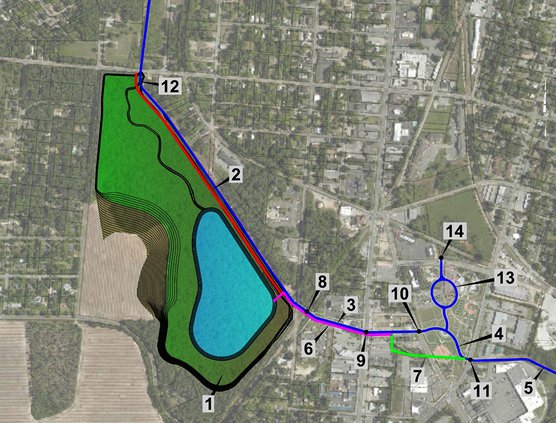
In the version envisioned by local developers and detailed in the study, the proposal would create a 26-acre reservoir in the Upper Little Lotts Creek Basin by building a dam running southeast from West Jones Avenue to South College Street near the railroad tracks.
Downstream, across College Street and South Main Street, the channel of Little Lotts Creek would be deepened and widened with a tiered cross-section to support creation of pedestrian walkway, or promenade, and park spaces. These, in turn, are meant to mesh with an eventual overhaul of Memorial Park at Fair Road and to spur private investment in surrounding commercial and residential development. A “Lonice Barrett Regional Recreational Park” with a dock, trails and picnic areas is suggested for the banks of the reservoir.
Phase 2 of the study has since been completed, with information on wetlands and “cultural resources,” such as historic structures, that may be affected, as well as water quality sampling and geotechnical analysis.
Kelley reported that 11 possible cultural resource sites have been identified, including some houses, an industrial complex, a shopping center and two railroads. Two sites qualify for National Register of Historic Places listing, he said, but added that these were apparently the railroads.
Wetlands impacted
The project area includes about 29 acres of wetlands, including 26 acres that would be covered by the reservoir.
“If a wetland exists and your project has to impact it in any way, then there are mitigation rules that have to be met,” Kelley said.
Local wetland mitigation bank credits would have to be purchased, the consultants stated.
They delineated the wetlands and streams and have maps of them for presentation to the U.S. Army Corps of Engineers.
Phase 3 of the study had been identified as the regulatory and permitting phase. The permits have not been obtained – a longer process than the single year of the study – but the consulting team has done much of the preparatory work for the permit applications, so the contracted feasibility study is essentially complete, said Statesboro City Manager Charles W. Penny.
Detailed estimate
The cost estimate range for the dam, the reservoir and its inlet and outlet structures is $27.6 million to $44.4 million. The range for the promenade and downstream infrastructure is $12.5 million to almost $20.2 million. Completing the permit process with the Army Corps of Engineers is projected to cost $100,000 to $200,000, and a Federal Emergency Management Agency map modification, $55,000.
Again, the overall project estimate was roughly $44.5 million, but the consultants allowed for a minus 10% to plus 45% variation to comply with Association for the Advancement in Cost Engineering standards for a feasibility study. So they cited a range of $40.2 million to $64.8 million, after also building in contingencies.
“Recognizing that we do have some funds but this is beyond the funds that we have, I would just say as the city manager, I appreciate the fact that they’re willing to come in and work with us to look at ways to make the project work, so today we’re not saying we’re done,” Penny told the elected officials.
The workshop to review goals for the project and look for ways to cut costs probably won’t be held until late February or early March, he said Tuesday.
Penny also said the cost estimates include some elements that the state might pay for separately, such as bridge replacement.