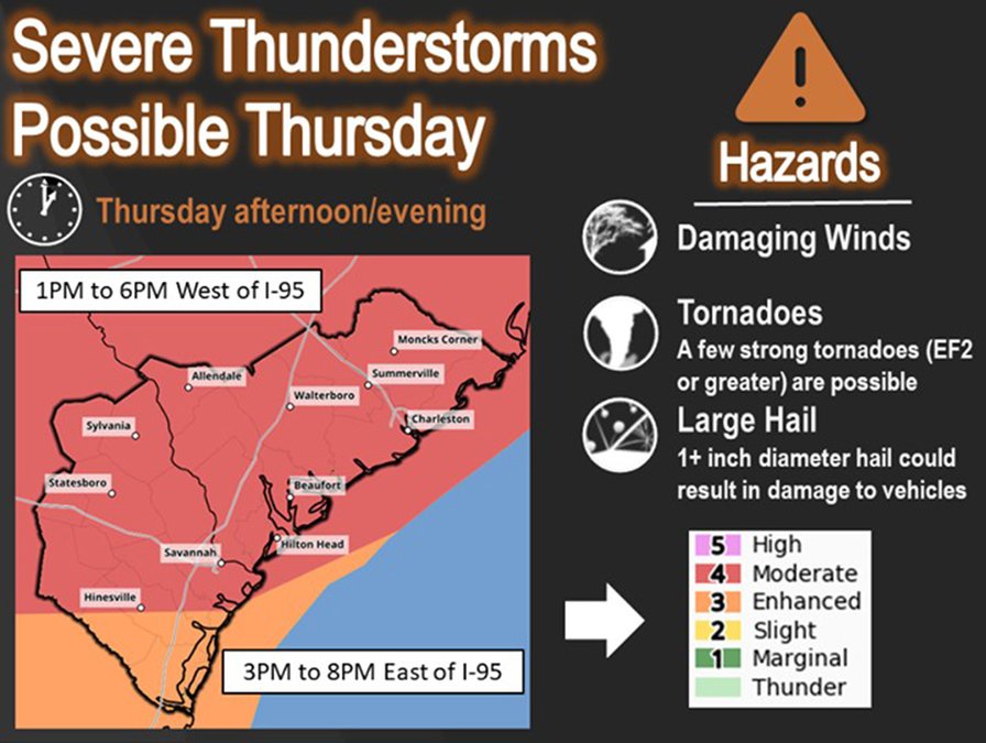

Bulloch County Public Safety/Emergency Management Agency Director Ted Wynn is urging area residents to closely monitor weather reports Thursday as a line of severe thunderstorms that could spawn tornadoes is forecast to impact Southeast Georgia.
“Significant severe weather is possible for us Thursday,” Wynn said. “The National Weather Service is advising that there is a possibility mainly between 1 p.m. and 6 p.m. Tornadoes and hail are also possible. Damaging wind gusts of over 58 MPH could occur taking trees down and causing some power outages.”
With the severe weather forecast, Bulloch County Schools announced Wednesday afternoon that schools would close early Thursday as a precautionary step and all after school activities would be cancelled.
“Schools will be open half-day, but parents can make the best attendance decisions for their family,” said Hayley Greene, public relations director for Bulloch County Schools.
Greene said the schools would follow the dismissal times below to accommodate bus routes and allow children to receive breakfast and lunch:
- Transitions Learning Center – 10 a.m.
- All elementary schools – 11 a.m.
- Cedarwood and Portal Middle High School – 11:15 a.m.
- Statesboro High, William James, and Langston Chapel Middle Schools – 11:45 a.m.
- Southeast Bulloch’s middle and high school – noon.
For Wednesday, the NWS issued a very rare Level 5 out of 5 “high risk” of severe thunderstorms for an area from Texas to western Georgia. For Thursday, the severe weather will move into the Southeast and Mid-Atlantic area and the NWS declared a Level 4 out of 5 risk of dangerous storms across the Carolinas and Georgia, including the Bulloch County area.
According to the National Weather Service, the elements for the outbreak include an intensifying low-pressure system drawing Gulf of Mexico moisture into the South as it tracks across the central and eastern states through Thursday. At the same time, the jet stream will take a deep plunge into the South.
These ingredients combine to provide the instability for thunderstorms and the wind shear needed to support supercell thunderstorms and tornadoes.
Wynn offered some practical steps to take to be ready for severe storms:
- Before severe weather strikes, know where to seek shelter so you can get there quickly, even in the middle of the night. This is particularly important if you live in a mobile home. You probably will need to leave a mobile home for either a community storm shelter or another building.
- Take every forecast, watch or warning about severe weather seriously, particularly if it is forecast overnight. It only takes one tornado or severe thunderstorm capable of, for example, downing a tree on your home, to pose a danger.
- Be sure you have multiple ways to receive severe weather watches and warnings. This could include a NOAA weather radio or your smartphone, which can sound an alarm to wake you at night when a severe weather alert is issued for your area. These alerts could provide the precious minutes needed to move quickly to shelter and may save your life.