
SAVANNAH - A hurricane watch covering nearly 200 miles along North Carolina's coast was issued early Wednesday, threatening Fourth of July plans as Tropical Storm Arthur moved northward from Florida.
Forecasts showed Arthur potentially skimming the Outer Banks, a string of narrow barrier islands prone to flooding but popular for beachgoers, on Friday as a hurricane.
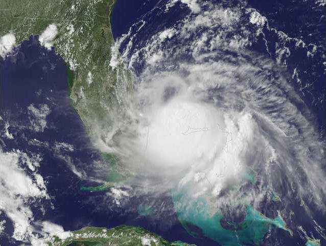
With Arthur about 100 miles (160 kilometers) off Cape Canaveral, Florida, and moving north at about 6 mph (9 kph), hotel owners, tourism officials and would-be vacationers all the way north to Virginia kept a watchful eye on forecasts. A tropical storm watch was in effect for parts of Florida and South Carolina.
The motel Shutters on the Banks in Kill Devil Hills, North Carolina, was completely booked for the holiday weekend, general manager John Zeller said Tuesday.
"We have received some cancellations but not too many," he said. "Basically we are telling people to kind of wait and see what happens. ... I think everybody is kind of watching the weather."
The storm's maximum sustained winds early Wednesday were near 60 mph (95 kph), and the National Hurricane Center said Arthur was expected to strengthen to a hurricane by Thursday.
"I think everybody's keeping one eye on the weather and one eye on the events this weekend," said Joe Marinelli, president of Visit Savannah, the city's tourism bureau.
Off Florida's Space Coast beaches - the closest to Arthur - the sky was cloudy and winds fairly normal Tuesday, said Eisen Witcher, assistant chief of Brevard County Ocean Rescue.
Red flags warned of rough surf, and beachgoers were advised to get into the water only in areas with staffed lifeguard stands. But overall, Witcher said, it was "business as usual."
Near the storm, 19 ill crew members were evacuated from a South Korean cargo ship Tuesday after they showed signs of food poisoning. The cargo ship JS Comet was anchored 3 miles off Cape Canaveral, and the Coast Guard reported that deteriorating weather conditions were one factor in the decision to evacuate.
On the Outer Banks, officials said they would close Cape Lookout National Seashore at 5 p.m. Wednesday and reopen when it's safe. Some motels said they'd waive cancellations fees if the storm continued to move toward the area.
In Folly Beach, South Carolina, dozens of people fished from the pier under sunny skies Tuesday. Others surfed on gentle swells, sunbathed and looked for shells.
In Savannah, rooms in the downtown historic district were expected to be at least 80 percent full for the holiday weekend, when crowds pack the beach on neighboring Tybee Island.
Cancellations aren't uncommon when storms approach, but those calls weren't coming in Tuesday, Marinelli said.
Amy Gaster said her Tybee Island vacation rental company had more than 200 beach homes and condos booked for the weekend, likely to be the busiest of the year. If forecasts start to show a serious threat, Gaster said her staff was prepared to send alerts to guests' cellphones.
But as long as Arthur stays offshore, she said her biggest concerns are rip currents and possible thundershowers on Thursday, when thousands are expected to pack the Georgia coast's largest public beach for fireworks.
"Hopefully Mother Nature is going to cooperate with us this year," Gaster said.